


Cap canaille 11 km

reymond83
User
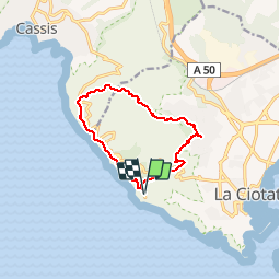

Length
10.9 km

Max alt
380 m

Uphill gradient
485 m
Km-Effort
17.3 km

Min alt
80 m

Downhill gradient
485 m
Boucle
Yes
Creation date :
2019-02-27 13:06:30.639
Updated on :
2019-02-27 13:07:59.246
--
Difficulty : Medium

FREE GPS app for hiking
 SityTrail
IGN / Geographical institutes
SityTrail Plus
The world is yours!
About
Trail On foot of 10.9 km to be discovered at Provence-Alpes-Côte d'Azur, Bouches-du-Rhône, La Ciotat. This trail is proposed by reymond83.
Positioning
Country:
France
Region :
Provence-Alpes-Côte d'Azur
Department/Province :
Bouches-du-Rhône
Municipality :
La Ciotat
Location:
Unknown
Start:(Dec)
Start:(UTM)
709185 ; 4783571 (31T) N.
Comments